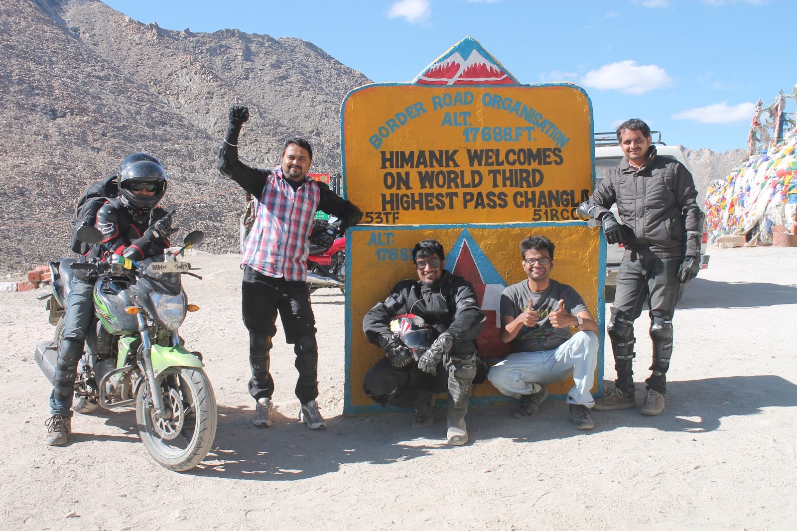
DAY 9 (DAY 6 OF BIKE
TRIP)
Date: 11th
August 2014
Route: Leh – Karu – Chang La -
Lukung – Spangmik
Distance
to be covered: 120 kms
Finally
the day arrived when we would be seeing the glorified Pangong Lake… Extremely
thrilled just by the thought of it...
After
having an heavy breakfast, we started our ride, this time accompanied by our
driver (backup vehicle) Thunduk and navigator Phunsuk. Road from Leh to Karu
was in a good condition and the journey was fast paced. Entire route was lined
with many petite villages and white Chortens (basic structure consists of a square
foundation symbolizing the earth, dome symbolizing water, and thirteen tapering
steps) which offered a
 |
| Engravings on the rocks |
scenic view of the arid Ladakh. We reached Karu
in less than an hour. On the opposite side of the check-post, where we halted
to get our documents and permit verified, we saw stones of
various shapes and sizes. On having a closer look, to my utmost surprise were minutely
detailed engravings on each and every stones…
 |
| Jaw dropping Landscape |
After enjoying
the view and some photography, we headed for Spangmik. The scenic beauty was
jaw-dropping; small channels of water accompanying us on our journey, barren mountains,
blue water surrounded with green pastures and horses grazing in these pastures.
We came across a river crossing with gushing muddy water making our ride
difficult… Pillions had to get down and find a way to cross the river… Riders
did a good job navigating the bikes through the water.
 |
| Serene Pangong Tso |
As we
were nearing Pangong Tso, my excitement grew. I was waiting to see those lovely shades of blue and when we reached I heaved a sigh of relief… Finally we
reached the Pangong
Tso before sunset (this was my Raksha bandhan gift from Sanujit). As
soon as I saw the lake I fell in love with the alluring beauty of the blue
water that I had never seen before. We could not take your vehicle till the
shore, so we had to walk down. We found an isolated place
 |
| Fun time at Pangong Tso |
to enjoy the serenity
of the lake. It was a challenge for us to walk; by the time we reached the waters it was dark and had started to get
chilly. We decided to sit there for a while; all we could see was water, water
and more water… for as far as your eyes can see. And then you see mountain range
that separates us from China, beyond which lies a larger portion of Pangong
Tso. It was a surreal view… We took some photographs and enjoyed the sound of
water which had a very soothing effect on me…. I also dared to soak my feet in
the ice cold water. Later on I had to suffer because of my impulsiveness. But
no regrets…
After spending time here, we headed for the pit
stop of the day i.e. Spangmik. From the lake till the village, the
road was bad with water crossing after every few feet of riding. Luckily we did
not come across black ice. Thanks to Thanduk, we easily got a decent homestay
(Padma Homestay) just a few minutes away from the lake. Homestays are far
cheaper and comfortable giving a very homely feeling. The house lady made us
one of the most delicious dinners we had till now. It was very cold and I couldn’t
wait to get under the duvets and hit the bed.
DAY 10 (DAY
7 OF BIKE TRIP)
Date: 12th
August 2014
Route: Spangmik – Merak
– Chusul – Chagga – Loma – Mahe – Karzok
Distance to be covered: 160 kms
 |
| Good Morning Pangong Tso |
In the
morning we got to enjoy the exhilarating view of sunrise sitting on the banks
of the crystal clear lake, the color of which changed from dark blue to
sapphire blue in front of our eyes… Simply mesmerizing… It was very refreshing
to stroll on the banks, soaking the magnificent view before heading for Karzok.
Today we were to explore a region where very few people have managed to reach…
Finally we
reached Merak
where we had to show the permits to cross Chushul. Going ahead we reached Khakste,
the last village before Chusul, here the Pangong Tso Lake turns into Tibet.
 |
| Heroic Land of Chushul |
Finally
we reached the Heroic Land Chushul, where we were again asked to show the
permits. We were a little concerned; whether we would be allowed to go further
even after having the necessary permit. It has happened earlier with some
travelers who were denied the entry even after having the permits and they had
to return back to Spangmik. Luckily we got a green signal to go further. We were informed that photography is
prohibited in whole inner line as per official
 |
| Roads??? Where??? |
rules as this region being too
close to the LAC. With the instructions from the army, we started for the
journey less taken… We were very excited at first but looking at the terrain, made
me little doubtful… It was so easy to get lost here due to lack of the actual
road or even a dirt road. Our only hope to reach the other side was our driver…
Slowly I started enjoying the solitude of the land of Borders. We could see the
China border on our left and remembered the warning given to us by the soldiers
at Chushul check-post that travelling towards the left, we would enter Chinese
Border and the things would get tough. Magnificent and massive mountains, blue
sky and stream playing peek-a-boo were our constant company. The beautiful ride
through barren land was interrupted by an event which was un-called for. One of
our bikes fell in the water while crossing a swollen stream with gushing water.
Luckily Sunit was not injured nor was he wet. But the bike refused to start up
even after making the bike stand vertically at 180o both on the head
light and on tail light for removing all the water from the carburetor… After
too many tries and a little help from the army soldier, we started our journey
again but we were delayed by 3 hours…
 |
Salute to Lt. Col. Nimbalkar
& Soldier Sanjay Singh |
We
ascended the hill to reach Chagga La, also known as Tsaga La. This pass goes
unnoticed due to lesser elevation and relatively gradual climb. While ascending
we came across a swollen stream with gushing water yet again. We were tensed to
cross the stream on bikes especially Sunit’s. Luckily a military gypsy passed
by and stopped to inquire about our trouble… Lt. Col. Nimbalkar and Soldier
Sanjay Singh got down and suggested that we should load Sunit’s bike in their
gypsy. Sunit’s bike safely reached the other side of the stream. Colonel
himself removed his shoes, rolled up his pants and stood in middle of the
stream to guide other two bikers to cross… They also offered us chocolates and
juice to carry with us… A very humble gesture by our soldiers just to ensure we
ride safely.... A big salute to them……
We
descended into the Tsaga village where we had to register at the
check post before heading towards Loma. Road from here till Loma was in pretty
good condition and the pillions were back on the bikes… The riders agreed that
the thrill of riding through Chushul on a bike was truly something! Though the
stretch was exciting but the pillions could not get that feeling in a car.
Everything beautiful seemed less stunning when seeing it from a car. But most
definitely what we saw around was dazzling… (I guess we were just missing being
on the bike!)
 |
| Myriads of colours |
We
reached Loma
in no time. On crossing the bridge on the left of the check post where we had
to register ourselves, was the Hanle (home to the
highest altitude Indian Astronomical Observatory)… How I wish we
could have managed to go there, but there’s always a next time… Roads from here were a mix of good and bad,
trying to find its way through mountains with different shades of brown, clear
blue sky with white fluffy clouds, brown soil turning to green pastures towards
the mountains…. On our way we saw black-necked crane. (These medium sized - mostly grey
colored with black head, neck and tail - migratory, legally protected
vulnerable birds come in this region every year for breeding).
We reached Mahe by late evening, where there was a
check-post and to the left was the Mahe bridge… Right after this bridge, the
road became bumpy, and ascent to some pass started. The ascent was not that
steep; however after crossing the pass suddenly the road disappeared and gave
way to dirt tracks until Karzok…. Again from here we asked our driver to drive
in front of the bikes…. Continuing on the dirt track, we came across a
bifurcation, from where we headed straight instead of going left… Proceeding
through the sandy & soft soil, the path was getting scarier. On top of it was the darkness….
We
reached Karzok
quite late at night… We stayed at Mentok Guest
House where we crashed after celebrating at midnight… Well the
celebration was for my second anniversary… At midnight Atul surprised
me by gifting me a beautiful Ladakhi neckpiece… He was equally surprised when I
opened the box of cookies and pastry…. All of us stayed up for some time and
retired to wake up fresh next morning.
DAY 11 (DAY 8 OF BIKE TRIP)
Date: 13th August 2014
Route: Karzok – Moore Plains – Tso kar –
Pang
Distance to be covered: 140 kms
 |
| Enjoying |
We headed to have a glimpse of Tso Moriri Lake… Wow!!! What a way to start our
anniversary… It is very difficult to express the gorgeousness of this lake in
words. I found this lake to be more
beautiful than the Pangong Lake. Also known as the ‘Mountain Lake’, this
exotic lake with its deep ultramarine water surrounded by golden mountains and
snow peaks gives a surreal experience. Endless vastness
 |
| Picturesque Mountain lake |
and sheer raw beauty of
this picturesque landscape gave us a
sense of untouched purity. The serenity that I experienced while standing in
the lake bare footed (super chilled water) made me feel out of this world. This
incredible place offered so much to capture in one glance. After spending some
time being one with the nature, we headed for Pang. I just couldn't stop
staring at it even while riding.
 |
| Deserted Roads to Tso Kar |
As the road were little rough, Me, Atul and Pranav decided to travel by
car so the riders would have little difficulty while riding bikes. The route
till Sumdo was same as we had taken the previous day to reach Tsokar. The road
improved a little bit compared to what we had faced earlier but it was still
jeep tracks with small rocks and pebbles. On crossing the Sumdo, we observed that the
roads were deserted; reminding me of Chushul.
 |
| Stunning Landscape |
The drive up from Sumdo to Tso Kar is incredible. For few hours and
few kilometers we were the only breathing creatures on 3 bikes and a 4-wheeler
on that road. The changing pattern in the terrain was simply stunning. After
driving through few twists and curves, the landscape unfolded itself and all we
could see barren mountains with snow peaks and Tso Kar Lake in front of us. The
lake was shimmering under the gaze of the sun and it appeared as if covered
with diamonds. The view was absolutely fabulous. Region around Tso Kar is a
wide open valley with a small road passing around it. The valley looks like a
desert, barren and dusty. We saw a herd of Kiangs near the lake and were dying
to take a detour and go near them, but due to time crunch we had to go ahead to
reach Pang on time.
 |
| On Moore Plains |
The roads improved a bit with only small pebbles scattered on the
road; however the roads were still bumpy and arrow straight. Travelling on this
road was awesome as compared to roads travelled earlier that day. But this
sense of relief was short-lived as we again started riding on dusty and bad
roads. Later I came to know that we had already crossed Moore plains… I was a
little disheartened as I had read a
 |
| Ibex Skull |
lot about it… We reached a small village
where we halted for tea and snacks. The most striking thing about this place was the
head of yak displayed on one of the houses… What a sight on entering the
village… We went to one of the food joints for lunch and there was a skull of
Ibex outside the entry of the tent.
 |
| Bikers of Mumbai and Pune |
Another thing which gained my attention
was the red color of the surrounding mountains as compared to the brown ones. Here we met some of the bikers from Pune and Mumbai. We exchanged our
experiences and we asked them if they have any spare petrol with them. We were
really low on petrol and were not sure if it would last till Pang. They gave us
5 lts of petrol and didn’t even take money us. That’s bikers’ spirit and I just
loved it… After spending some time chit chatting with the boys, we headed
towards Pang.
The road from the village till a junction, where the road from Leh
meets this route, was super smooth and we reached the junction in no time. On
reaching the junction, we decided to buy petrol from the small dhabawallas on
the road. The petrol was super expensive; we tried to bargain but ended up paying
whatever they asked for. The road till Pang was as good as ever except the last
10 kms where the road was bad and extremely bumpy.
 |
| Experimental photography |
We reached Pang
by night. It is the world’s highest Military Transit Check point. We stayed at Padma home stay which was a small concrete house having
dormitory and 3 tents. It was chilly out there and difficult to be out in the
open. Till our dinner was being made, we decided to experiment night
photography. We also saw Milky Way which we tried to capture on camera but we
failed to do so. The dinner was awesome and after long we were watching hindi
serials. Post dinner we were off the bed.


0 comments:
Post a Comment